
The dew point is the temperature air must cool to at a constant pressure in order for saturation to occur with respect to a liquid surface. The frost point is the temperature air must cool to at a constant pressure in order for saturation to occur with respect to an ice surface. When temperature and dew point of air are given, the dew point is NOT equal to the frost point and this has important analysis and forecast implications. It is more difficult for water vapor to leave an ice surface than it is for water vapor to leave a liquid surface. Think of ice as being more rigid with less energy as compared to liquid. Since ice has less energy it is more difficult for an ice molecule to gain the energy needed to leave the ice surface as water vapor. Because of this the saturation vapor pressure over liquid water is greater than the saturation vapor pressure over ice at the same temperature. Think of an ice crystal next to a supercooled water drop at a temperature of -5 C. More water vapor will leave the liquid surface than the ice surface. This creates an imbalance in vapor pressure. Just as air moves from high to low pressure, vapor will move from higher vapor pressure toward lower vapor pressure. The excess vapor will move closer to the ice. This creates supersaturation with respect to the ice surface and the ice will grow by taking water vapor from the air to try to equalize the imbalance in vapor pressure. A forecast implication of the difference in saturation vapor pressure between ice and water at the same temperature is that frost can begin to develop on the ground before the temperature cools all the way to the dew point. The dew point may be 20 F in a particular situation but frost can start developing on the ground when the temperature is a few degrees above 20 F. The frost point is higher than the dew point. The frost point is higher than the dew point since air will be supersaturated with respect to an ice surface before the temperature cools all the way to the dew point An analysis implication arises when using the Skew-T Log-P diagram. The dew point plotted on the Skew-T is with respect to a liquid surface. When the temperature is below freezing the dew point will continue to be plotted instead of the frost point. This can give the appearance that air that is saturated does not look saturated with examining the Skew-T. Suppose at 500 millibars the temperature is -17 C with a dew point of -20 C. This air may appear unsaturated and it is with respect to a liquid water surface. However, the air may be saturated with respect to an ice surface. Remember the frost point is higher than the dew point. Thus, the frost point is WARMER than -20 C and will be much closer to the temperature of -17 C. There could still be clouds composed of ice crystals in this air. The temperature and dew point lines in saturated air will commonly diverge with height once the temperature drops significantly below freezing. This diverging is the difference between the dew point and frost point. Examine the sounding below. Notice once the temperature drops significantly below freezing that the dew point and temperature lines spread apart even though this is a situation in which the middle and upper troposphere is covered in cloud. There is a tendency for cloud droplets that are between 0 and -10 C to be supercooled which means the droplets are still liquid even though the temperature is below freezing. Once temperatures drop below -10 C then it becomes increasing more common for ice to be present. This is why the spreading between dew point and temperature is not as clearly evident until the temperature has dropped below -10 C. 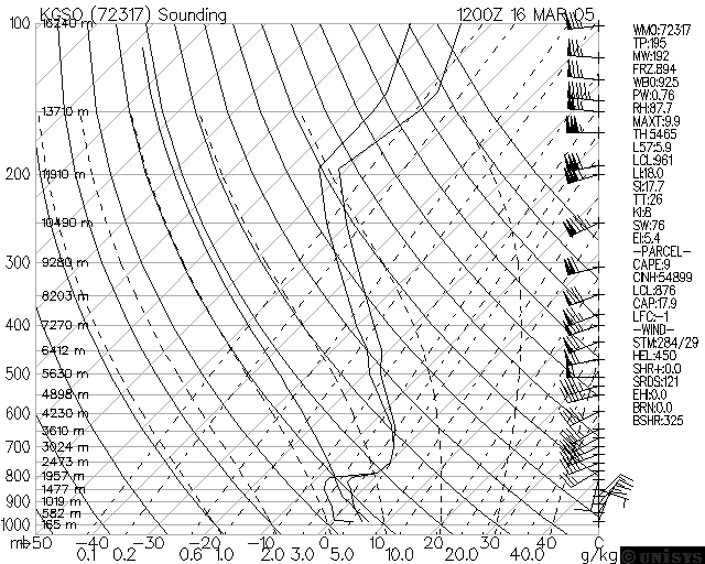
|