
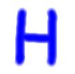
 High Pressure System: This is a region of relatively higher pressure. There will often be sinking air and thus stable weather. Sunny weather will often occur under high pressure. High pressure is colored in blue. The choice of the color blue has nothing to do with temperature. High pressures can bring with warm or cold weather depending on the type of high pressure it is. 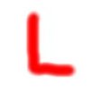 Low Pressure System: This is a region of relatively lower pressure. There will be rising air and thus often there will also be clouds and precipitation. Low pressure is colored in red. The choice of the color red has nothing to do with temperature. While it is typically cooler under a low due to the the cooling from cloud cover as well as rain or snow, temperatures can vary between being mild to being very cold. 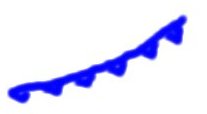 Cold Front: A cold front indicates a colder air mass is moving in the direction toward which the triangles are pointing. The cold front is drawn at the leading edge of the cold air mass. When the cold front passes the temperature drops and the rising air along the front can bring precipitation especially in the region where the cold front is approaching. 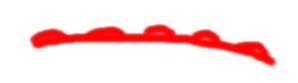 Warm Front: A warm front indicates a warmer air mass is moving in the direction toward which the semicircles are pointing. The warm front is drawn at the leading edge of the warm air mass. A warm front can also bring precipitation especially in the region where the warm front is approaching. 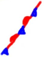 Stationary Front: A stationary front separates a warmer from a cooler air mass. A stationary front has a little or no movement thus the cold and warm front symbols are drawn in alternating fashion. 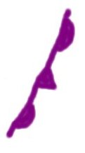 Occluded Front: An occluded front is drawn in purple. It is a cold front that overtakes a warm front. They commonly occur close to a maturing low pressure system. |